Lessons learned from the Ecowende drone pilot
Hermione van Zutphen, Ecowende (2026)
First BVLOS flight to an offshore wind farm outside the 12 NM zone
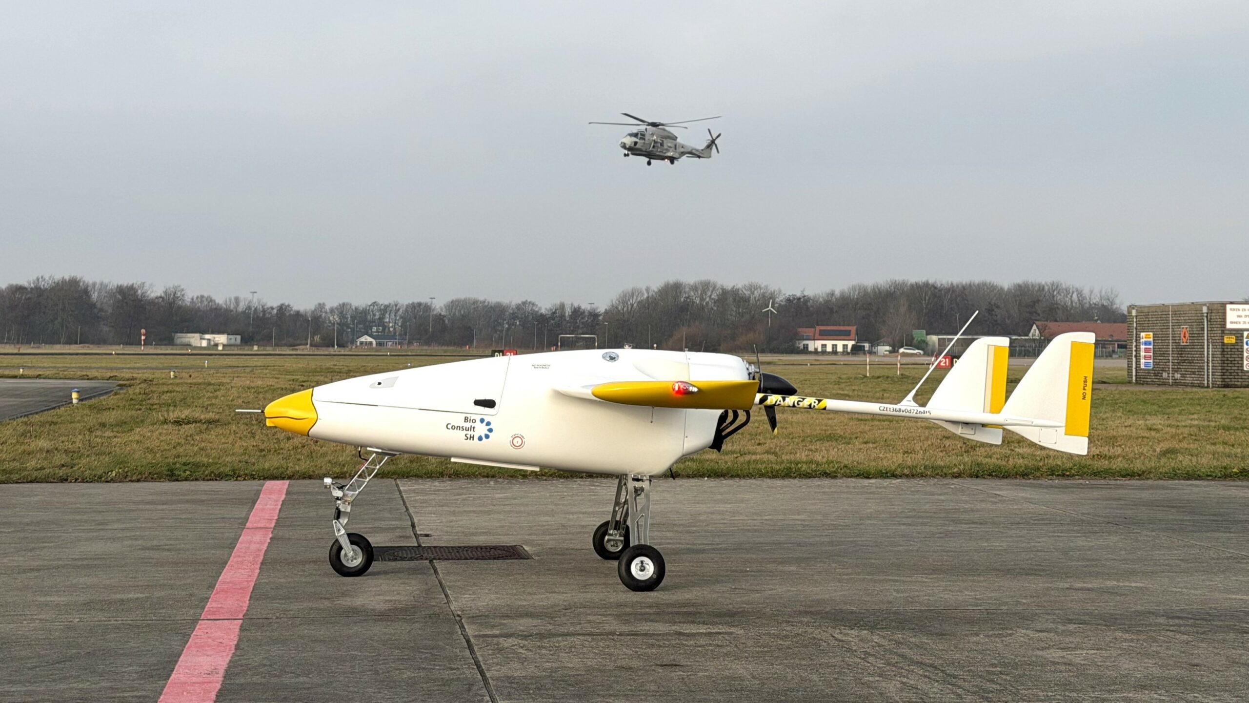
On Tuesday 20 January 2026, Czech drone operator Primoco carried out the first test flight on behalf of Ecowende partners BioConsult SH and HiDef Aerial Surveying, to map marine life in and around Ecowende's offshore wind farm area. The mission used the Primoco One 150, a lightweight unmanned aerial vehicle (UAV) fitted with specialised cameras. The drone took off from Den Helder Airport and followed a pre-programmed route to Ecowende's Hollandse Kust West wind farm zone, roughly 53 kilometres off the coast of IJmuiden.
Replacing manned aircraft with drones reduces both emissions and risk: inspection and survey flights over offshore wind farms no longer require a crew on board. The potential is clear. But this pilot didn't happen overnight, and the lessons it produced are valuable for scaling up offshore drone operations.
Now that the flight has been evaluated, what did we learn, and what is needed to make this kind of operation a standard part of the future? You can read it in this report.
Navigating the regulatory grey area
The biggest challenge was regulatory. Within the 12 NM zone, a drone operates under EU regulations 945/2019 and 947/2019. Beyond that line, it enters international airspace governed by ICAO rules — a framework originally designed for manned flight. A drone pilot flying beyond visual line of sight in non-segregated international airspace doesn't neatly fit that framework, and the flight was initially not permitted.
After a careful review of the ICAO T070 annexes, the following steps were taken to resolve the impasse:
Registration and certification of the drone. This falls under national policy and differs by country. The Czech Republic, where Primoco is based, allows drone registration; the Netherlands currently does not. National regulations need to be amended and standardised to enable a consistent approach across countries.
Additional onboard safety systems. To safely execute the flight in busy airspace — and respond well if something goes wrong — the drone was fitted with ADS-B and FLARM in/out, a redundant C2 link, an onboard VHF radio, an emergency procedure to switch the C2 link to squawk 7200, and a ballistic parachute system.
Careful preparation and risk assessment. An initial flight was used purely to check the safety systems; the full survey only followed once all checks were complete. This required close collaboration between the flight operator, the airfield, the military, the Dutch regulator, and Dutch air traffic control. Other flight and marine operators in the vicinity of the survey area were also notified before and during the operation.
Preparing for flight
Preparation required a significant amount of person-to-person communication to keep every stakeholder informed and secure the necessary approvals. Not surprising for a first-of-its-kind operation — but this level of manual coordination isn't sustainable once drone flights become a routine part of operations. Standardising approval processes and stakeholder management is essential going forward.
Communication between the drone and ground control runs through a C2 (Command and Control) link. The initial frequency permit was valid for only two weeks, which meant repeated paperwork and extra cost whenever the operational window shifted. Going forward, extending the validity of these permits will make the process easier and more cost-efficient.
Ground operations also required adjustment. As the pilots remain at the ground control station during flights, arrangements had to be made for facility access, registration and induction of flight technicians, and the positioning of the drone ground control van. After the first test flight, the van's position was adjusted to reduce signal shielding from hangars and other large structures nearby.
The final go/no-go for each flight depended on weather conditions. As with manned flights, the strictest weather limits apply to take-off and landing; the nature of the aerial survey also made cloud cover an additional restriction. Carrying out regular surveys throughout the year, including the winter months, will likely require a mix of manned flights and drones to maximise operability.
During the operation: patchy coverage at sea
During the flights, radio and radar coverage proved patchy in places. Two offshore platforms that carried LVNL radio and radar equipment have since been removed, leaving part of the North Sea with reduced or no coverage. As these radar stations will not be replaced, this remains a point of attention that requires an alternative solution.

Recommendations for standardised operations
Based on the feasibility flight and the two surveys over the Ecowende wind farm, the following recommendations were identified to operationalise drone flights and surveys going forward:
1. This mission provides a blueprint, showing that with a minimum set of equipment — ADS-B in/out, transponder and a flight plan — operations can be carried out safely.
2. Given ICAO regulations, aircraft registration needs to be standardised and generically applicable across EASA countries.
3. Communication between, and the number of, stakeholders involved needs to be simplified.
4. Provision needs to be made for multiple drones operating at once, including alongside helicopters — both for point-to-point flights and for surveys flown along planned transects.
5. Access to the coast could be simplified, for example through a dedicated corridor or shared use with helicopter operations. Improvements to onboard technology, moving from See & Avoid to Detect & Avoid, would support this and could enable a future corridor to the coast shared by drones and helicopters.
6. Operations in and around wind farms could benefit from an adapted airspace status, or even an ATZ (Aerodrome Traffic Zone), similar to the HTZ (Helicopter Traffic Zone) used around offshore platforms.
7. Civil radar coverage over the North Sea requires alternative infrastructure to close existing gaps.
8. Publishing an AIC (Aeronautical Information Circular) specific to BVLOS drone operations outside the 12 NM zone is being considered, to set out the current and future framework, including rules, restrictions and limitations, with scope to update it as arrangements develop.
9. In parallel, a clear AIP (Aeronautical Information Publication) should be developed for drones operating within and beyond the 12 NM zone, similar to existing AIPs for helicopters, including routings and designated areas.
10. Operations need to be prepared for non-standard situations and emergency procedures.
Conclusion
When Ecowende and partners began this journey, it wasn't yet clear everything it would take to make aerial surveys more sustainable and future-proof. The benefits are now evident: a smaller carbon footprint, less exposure of personnel to offshore and aviation risks, and the opportunity to gather more and higher-quality data. Pursuing drones for future operations is a clear choice.
With this first flight, we've shown that BVLOS drone flights across the 12 NM zone are possible. That would not have happened without the cross-border collaboration of everyone involved. Our thanks go to LVNL, DGLM, the Ministry of Infrastructure and Water Management, Den Helder Airport, the Ministry of Defence, and of course Ecowende's partners HiDef, BioConsult, Primoco and the experts from Shell Aviation.